ExpertGPS Specifications
|
Track your GPS waypoints and view topography maps and aerial photos.

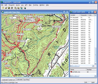
ExpertGPS mapping software for Garmin, Magellan, Lawrence, and Brunton GPS owners is your direct connection to the complete set of USGS topo maps and aerial photos. ExpertGPS displays your way points, routes, and tracks on USGS topo maps and aerial photos. Using the mapping tools in ExpertGPS, you can draw your route directly on a map, search for nearby features from the millions of way points available in our database, and transfer your trip directly to your GPS.
Shop your favorite products and we’ll find the best deal with a single click. Designed to make shopping easier.
Create, edit, and transfer waypoints and routes between your computer and your Garmin, Magellan, or Lowrance GPS.
Plan routes and perform real-time GPS navigation on land, sea, and in the air.