Display waypoints, routes, and tracks in an interactive map.
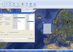
GPSmapview allows you to display Waypoints, Routes, or Tracks loaded from many file formats in an interactive map. Use it to see where you've been, plan where you're going, or visualize geographic data. In addition GPSmapview can Print or export your maps in JPEG format. Four kind of maps are available to display your geographic data: simple map, streets map, ...
Redirecting to a secure site. We are checking If the link is working. Please wait...
You can report broken links into broken@dailydownloaded.com. Our editors will review them shortly.
Download maps from Google Maps, Yahoo Maps, Bing Maps, or OpenStreet Maps.
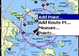
Plan routes and perform real-time GPS navigation on land, sea, and in the air.